


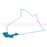
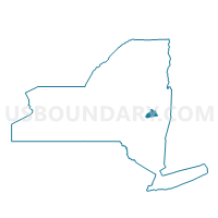
Voting District 010005, Schenectady County, New York
About
Outline

Summary
| Unique Area Identifier | 636676 |
| Name | Voting District 010005 |
| County | Schenectady County |
| State | New York |
| Area (square miles) | 15.24 |
| Land Area (square miles) | 15.06 |
| Water Area (square miles) | 0.18 |
| % of Land Area | 98.80 |
| % of Water Area | 1.20 |
| Latitude of the Internal Point | 42.73353360 |
| Longtitude of the Internal Point | -74.23363100 |
Maps

Graphs
Select a template below for downloading or customizing gragh for Voting District 010005, Schenectady County, New York


Neighbors
Neighoring Voting District (by Name) Neighboring Voting District on the Map
- Voting District 010002, Schenectady County, NY
- Voting District 010003, Schenectady County, NY
- Voting District 010004, Schenectady County, NY
- Voting District 060001, Schoharie County, NY
- Voting District 060002, Schoharie County, NY
- Voting District 090002, Albany County, NY
- Voting District 120002, Schoharie County, NY
- Voting District 160001, Schoharie County, NY
Top 10 Neighboring County Subdivision (by Population) Neighboring County Subdivision on the Map
- Duanesburg town, Schenectady County, NY (6,122)
- Schoharie town, Schoharie County, NY (3,205)
- Knox town, Albany County, NY (2,692)
- Esperance town, Schoharie County, NY (2,076)
- Wright town, Schoharie County, NY (1,539)
Top 10 Neighboring Place (by Population) Neighboring Place on the Map
- Duanesburg CDP, NY (391)
- Delanson village, NY (377)
- Esperance village, NY (345)
- Duane Lake CDP, NY (323)
Top 10 Neighboring Unified School District (by Population) Neighboring Unified School District on the Map
- Schoharie Central School District, NY (6,725)
- Berne-Knox-Westerlo Central School District, NY (6,602)
- Duanesburg Central School District, NY (5,119)
Top 10 Neighboring State Legislative District Lower Chamber (by Population) Neighboring State Legislative District Lower Chamber on the Map
- Assembly District 105, NY (137,005)
- Assembly District 104, NY (132,644)
- Assembly District 127, NY (129,764)
Top 10 Neighboring State Legislative District Upper Chamber (by Population) Neighboring State Legislative District Upper Chamber on the Map
- State Senate District 44, NY (317,410)
- State Senate District 46, NY (304,204)
- State Senate District 51, NY (296,420)
Top 10 Neighboring 111th Congressional District (by Population) Neighboring 111th Congressional District on the Map
Top 10 Neighboring Census Tract (by Population) Neighboring Census Tract on the Map
- Census Tract 331.02, Schenectady County, NY (6,122)
- Census Tract 7407, Schoharie County, NY (5,285)
- Census Tract 7401, Schoharie County, NY (5,281)
- Census Tract 147, Albany County, NY (2,692)